Protecting Water Sources in Ecuador for Conservation
07/12/2022
Focusing on water source protection simultaneously preserves sites of hydrologic importance and surrounding biological, and cultural diversity.
Water connects people to conservation.
Access to clean water is a basic human necessity and preserving important water sources is a powerful tool for encouraging overall ecosystem health. Nature and Culture leverages local interest in preserving access to clean, abundant water to drive conservation. Ultimately this leads to the preservation of local biodiversity, nearby forests, ecosystems, and food security for local populations.
<!–more–>
In Ecuador, a Water Protection Area (WPA) is a nationally recognized, legally protected territory that conserves these precious water sources.

WPAs ban exploitative activities, ensuring clean water supplies for local communities and preserving surrounding wildlife.
These areas are established based on their strategic importance as water sources for human consumption and/or to guarantee food security. Once an area achieves this status, it is legally protected from activities like mining and other destructive activities such as unsustainable agricultural practices which can inhibit or drastically limit groundwater stores.

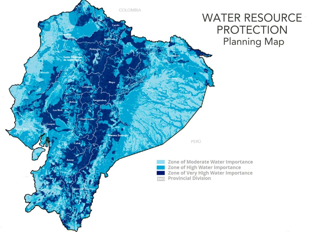
Early in 2021, Nature and Culture developed a national water protection planning map in coordination with the National Water Authority of Ecuador.
This map establishes areas of hydrologic importance for human consumption and food security in the country.
In order to identify and prioritize areas of water importance, Nature and Culture conducted technical studies using multi-criteria analysis and geographic information systems (GIS) to map the data. 48,368 square miles, primarily in the Sierra (mountain region) and the central and northern Amazon of Ecuador were determined to be of high value for their water resources.
As of the declaration of the Quilanga WPA early this year, we have protected 9 of 10 areas that the Ministry of Environment and Water has invited Nature and Culture to support, with many more in the early planning stages for the near future.

Important water sources have been gaining attention due to recent protests in Ecuador. Many Indigenous leaders held a strike to ask the Ecuadorian government to stop all mining concessions near important water sources, among other demands. In June 2022, a peace agreement between the Ecuadorian government and the country’s leading Indigenous organizations was brokered. Part of this agreement proposes a stop to all mining activity in protected areas and ancestral territories, national parks and Water Protection Areas. This is the beginning of an important dialog around environmental policies in favor of all Ecuadorians.
The findings from our Water Protection Area National Planning Map can support discussions between Indigenous leaders and the Minister of Environment to continue to protect remaining areas of high and very high water importance.
Read more on our response to current events in Ecuador here.


